Last updated: October 14, 2026 — Publication and capture-date wording clarified; viewpoint, coastal context and article-specific FAQs updated from official sources. Original publication: August 9, 2014; exact capture and travel dates remain unverified.
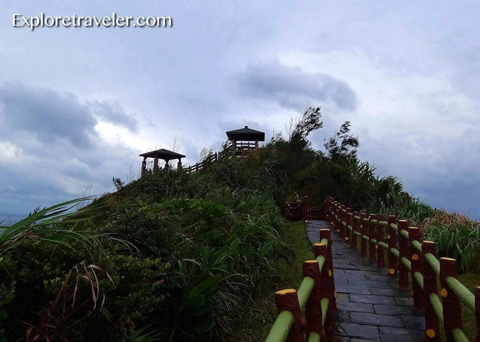
Haishengping Bay (海參坪) is a crescent-shaped coastal bay on the eastern side of Green Island (Ludao), Taitung County, Taiwan. The Little Great Wall trail leads toward a pavilion overlooking this coast. ExploreTraveler first published this photograph on August 9, 2014. It shows the viewpoint path climbing through coastal vegetation toward pavilions above the bay; the camera’s capture date is not recorded in the available image metadata.
What is Haishengping Bay?
Haishengping Bay is part of Green Island’s volcanic coastline. The scenic-area administration’s English Haicanping guide describes a moon-shaped coral-reef gulf formed from volcanic rock, with unusual coastal shapes associated with reef and water erosion.
The East Coast National Scenic Area Administration identifies Haishengping on the middle of Green Island’s east coast and describes the Little Great Wall trail and pavilion as the viewpoint route. These official sources are the best places to confirm current access information before a visit.
What the archived photograph shows
The photograph looks up a paved path bordered by red-and-green railings. Wind-shaped vegetation fills the slope, and several small pavilions sit along the ridge beneath a cloudy sky. The frame records the approach to the viewpoint rather than the full bay panorama.
Our original caption began, “Steps to a perfect view over looking Haishengping Bay, Green Island.” That is the focus of this photo story: the path and the promise of the outlook beyond it. The image preserves an ExploreTraveler view of the place, while the official sources below provide separately researched location and landscape context.
Planning a Haishengping Bay visit
- Location: eastern Green Island, also called Ludao, off the coast of Taitung County.
- Viewpoint: follow the signed Little Great Wall route to the pavilions overlooking the coast.
- Island context: Taiwan’s Tourism Administration Green Island guide says the island’s 16.3-kilometer round-island highway connects its principal scenic stops.
- Before leaving: check the linked official tourism pages for current access, transport and weather notices. This archived photograph is not a live conditions report.
Just north of Haishengping, the scenic-area administration’s official Youzihu guide documents an abandoned fishing settlement and traditional coral-stone houses. It provides useful historical context for travelers exploring this side of Green Island.
The Little Great Wall viewpoint walk
Researched visitor context — checked October 14, 2026: The scenic-area administration’s Haishengping guide describes the Little Great Wall as a roughly 400-meter trail on the bay’s northern hillside. It winds along the ridge to a viewing pavilion on the headland. Seen from a distance, the route resembles a small version of the Great Wall, which explains its name.
The administration’s separate Pekingese Dog and Sleeping Beauty guide calls the roadside-to-pavilion path steep. That is useful context when deciding whether this is the right stop for your group: a short distance does not describe the effort of the climb. Neither the original caption nor this archive records a measured walking time. The 400-meter trail should also not be confused with the 16.3-kilometer road around Green Island; one is a viewpoint approach, the other connects scenic stops across the island.
Reading the coastal rock formations
The official guides give names to several shapes around Haishengping, including Sleeping Beauty, the Pekingese Dog, Fairy Stones and Confucius Rock. The rock-formation guide explains that names such as Sleeping Beauty and Pekingese Dog come from the objects the formations resemble.
The Chinese-language Haishengping description identifies Fairy Stones as layered, pyramid-like rocks along the bay and Confucius Rock as a separate sea stack below the southern cliffs. It describes a coast where headlands, bays, sea cliffs, fringing reefs and eroded rock formations occur together. Those details help explain why a viewpoint is useful here: it gives context to features spread across the coastline. The archived image on this page shows the approach, so it should not be used to identify every named formation.
Youzihu: nearby settlement and archaeological history
The official Youzihu guide adds another layer to this eastern-coast story. Beyond its old fishing settlement and coral-stone houses, Youzihu is an important prehistoric site. The administration reports archaeological finds including animal and fish bones, shells, pottery fragments, burials and shell mounds. It describes those discoveries as evidence relevant to earlier contacts with groups in eastern Taiwan and the Hengchun Peninsula. This is researched historical context for a neighboring place, not a claim that these finds or the settlement appear in John’s photograph.
A useful place to learn about the landscape
For more background before exploring the coast, the Tourism Administration’s Green Island page describes the visitor center opposite the airport exit. Its permanent displays include geological samples, information about local plants and animals, and underwater photography; the page also describes a multimedia room showing films. That makes it a useful official starting point for understanding how the island’s land and sea landscapes fit together.
Frequently Asked Questions
Where is Haishengping Bay, and is Haicanping the same place?
Haishengping Bay is on the middle part of Green Island’s east coast in Taitung County, Taiwan. Green Island is also called Ludao. The scenic-area administration uses “Haicanping” on its English bay page and 海參坪 on its Chinese page. These pages describe the same bay and Little Great Wall viewpoint, rather than two different island stops.
How long is the Little Great Wall trail?
The official rock-formation guide describes a 400-meter approach. The companion rock-formation page describes the roadside-to-pavilion climb as steep. This archive does not provide a personally timed walk or establish step-free access.
What are Sleeping Beauty and the Pekingese Dog?
They are names for coastal rock formations associated with the shapes they resemble. The official guide connects the Little Great Wall pavilion with views of these geological features. They are part of the wider landscape, not subjects that this path photograph clearly documents.
Is Youzihu another name for Haishengping?
No. The administration places Youzihu north of Haishengping. It is a neighboring former fishing settlement with traditional coral-stone houses and prehistoric archaeological significance. Read the separate guide if that history interests you; the two place names should not be treated as interchangeable.
Continue exploring Green Island
- Read ExploreTraveler’s broader Green Island, Taiwan adventure.
- Explore three Green Island food dishes.
- Visit the ExploreTraveler photography page.
Sources and update scope
Location, viewpoint and coastal-history context were checked on October 14, 2026 against the linked East Coast National Scenic Area Administration and Taiwan Tourism Administration pages. The earlier Taitung Tourism Department reference is retained, but its substantive text was not retrievable in this check. Original publication: August 9, 2014. The exact capture and travel dates remain unverified; this is not a report of present trail, tide or weather conditions.